_edited.png)
Warora’s Forgotten Past: From Vakataka Roots to the Coal Age Pulse
- Pranay Arya

- Oct 21, 2025
- 14 min read
Warora stands at the crossroads of history and industry in Chandrapur district, bearing witness to centuries of transformation that shaped the Vidarbha region.
This municipal council town, positioned approximately 47 kilometres west of the district headquarters, has evolved from an ancient settlement with Vakataka era connections to a crucial coal mining centre during British colonial rule.
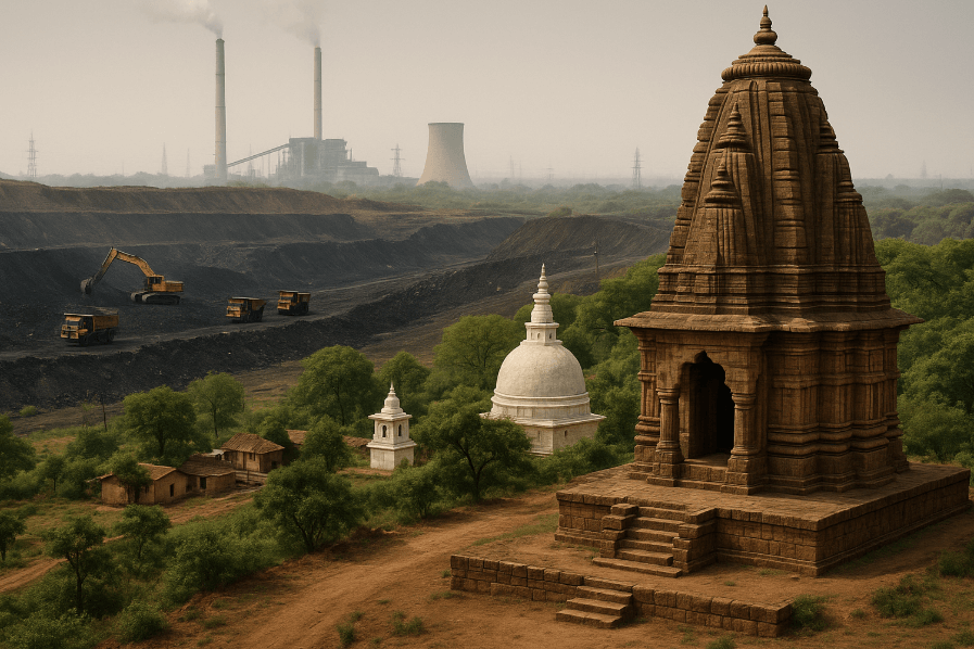
The town's geographical location in the Wardha Valley Coalfield determined much of its modern identity, yet beneath the industrial landscape lies a complex history of dynasties, rulers and social movements.
Today, Warora encompasses an area of roughly 1,520 square kilometres within its taluka boundaries, supporting a population that has grown alongside its economic activities.
The town remains known not only for its coal reserves but also for Anandwan, the rehabilitation centre established by social worker Baba Amte in 1949.
Ancient Foundations and Medieval Power
The earliest references to Warora emerge from inscriptions related to the Vakataka dynasty, which ruled over central India and the northern Deccan plateau from the mid-3rd century CE to approximately 550 CE.
The dynasty, founded by Vindhyashakti around 250 CE, established itself as the most important successor to the Satavahanas in the Deccan region.
Archaeological evidence from the Maharashtra Gazetteers identifies the river Hiranya, mentioned in ancient copper plate grants, as the modern Erai, which flows through Warora tahsil.
One significant Vakataka inscription refers to Ekarjunaka, identified with modern Ekarjuna on the left bank of the Erai river, located merely two kilometres from present-day Warora.
The Vakataka Empire reached considerable territorial extent under its rulers, stretching from the southern edges of Malwa and Gujarat in the north to the Tungabhadra River in the south, and from the Arabian Sea in the west to the edges of present-day Chhattisgarh in the east.
Their capital at Nandivardhana, identified with modern Nanded near Ramtek, placed Warora within the geographical sphere of this powerful dynasty.
The Vakatakas maintained close relations with the Gupta Empire, with Emperor Chandragupta II marrying his daughter into the Vakataka royal family, leading to a period of relative peace and cultural exchange in the region.
Following the decline of the Vakatakas, the region witnessed the rise of various dynasties, including the Kalachuri during the 6th and 7th centuries CE, the Rashtrakuta dynasty between the 7th and 10th centuries, and the Chalukya dynasty until the 12th century CE.
The Seuna dynasty of Devagiri ruled a kingdom that included the Chandrapur area from approximately 850 CE until 1334 CE. An inscription at Ambe from 1228 CE records how King Singhana II's general Kholeswar defeated a Paramar King of Chandrapur, establishing Yadava rule over the region.
The political landscape underwent a dramatic transformation following the fall of the Yadavas of Devagiri and the Kakatiyas of Warangal at the hands of Ala-ud-din Khilji in the early 14th century. This watershed moment paved the way for the rise of Gond political power in Chandrapur.
According to historical records compiled by Major Lucie Smith in his Settlement Report of Chanda District from 1869, the Gond kings established their original seat at Sirpur, located twenty miles south-west of Chandrapur proper, on the southern bank of the Painganga river. From Sirpur, they eventually shifted their capital to Ballarsah and finally to Chandrapur.
The Gond kingdom maintained control over the region for several centuries, with a genealogy tracing rulers from Bhim Ballal Sing around 870 CE through successive generations.
These tribal rulers established sophisticated administrative systems and maintained their authority over the forested territories of central India.
The kingdom reached its zenith under various rulers, including Dhundya Ram Sah, who ruled from 1522 to 1597 and constructed the ancient temple at Bhatala near Warora during the 16th century.
The Bhonda Mahadev Temple, featuring the largest Shivling in the Vidarbha region, stands as a testament to Gond patronage of Hindu religious architecture.
Maratha Conquest and British Annexation
The independent Gond kingdom met its end in the mid-18th century through Maratha expansion. In 1730, Raghoji I Bhonsle of Nagpur marched on Chandrapur but refrained from invasion upon finding the ruler Ram Shah to be a saintly and pious person.
However, Ram Shah's successor, Nilkanth Shah, who ruled from 1735 to 1751, proved less fortunate. Contemporary accounts describe Nilkanth Shah as a tyrant given to vices who executed his father's trusted minister, Mahadajee Vedya and interfered in the politics of neighbouring Deogarh.
When Raghoji I Bhonsle was occupied with military campaigns in Bengal around 1748, Raghunath Singh, the minister of the King of Deogarh, rebelled with assistance from Nilkanth Shah. Upon returning from the Bengal expedition, Raghoji invaded Deogarh in 1748, killed Raghunath Singh, and assumed complete control of Deogarh's administration.
He subsequently turned his attention to Chandrapur, defeating Nilkanth Shah and forcing him to sign a treaty dated 1159 Phasali year, corresponding to 1749 CE, which ceded two-thirds of the kingdom's revenue to the Marathas.
In 1751, when Nilkanth Shah rebelled against this arrangement, Raghoji I Bhonsle defeated him with ease and permanently imprisoned him in Ballarpur Fort. This decisive action brought the Gond house of Chandrapur to an end, and the region passed directly under the rule of the Bhonsles of Nagpur. Warora, falling within the territories controlled from Chandrapur, thus became part of the Maratha political system that dominated much of 18th-century India.
The Bhonsle ruled over Chandrapur district from 1751 until 1853, though their independent status had already been compromised by 1818 following the Third Anglo-Maratha War. After defeating the Marathas, the British established their paramountcy over the Nagpur kingdom, which continued under indirect rule. The situation changed dramatically in 1853 when Raghoji III Bhonsle died without a male heir.
The British Governor-General Lord Dalhousie applied the notorious Doctrine of Lapse, which stipulated that any princely state without a natural heir would be annexed to British territories.
Consequently, the entire Raj of the Bhonsles, including Chandrapur and Warora, fell to British control. On 18 December 1854, the administration of Chandrapur was formally taken over by R.S. Ellis of the Madras Civil Service, who became its first Deputy Commissioner. In 1854, Chandrapur was constituted as an independent district, and by 1874, it comprised three tehsils, namely Mul, Warora and Bramhapuri.
The creation of Warora as a separate tehsil headquarters reflected the administrative reorganisation undertaken by British authorities to facilitate revenue collection and governance.
During the British Raj, Warora formed part of the Central Provinces, a vast administrative unit created in 1861 by merging the Saugor and Nerbudda Territories with Nagpur Province. In 1903, the region of Berar was added, creating the Central Provinces and Berar. This province remained under British control until independence, with Nagpur serving as its capital.
The district boundaries underwent several modifications during this period, with territorial exchanges occurring in 1907 when portions of Lower Sironcha tehsil were transferred to Madras Presidency.
Coal Discovery and Industrial Transformation
The industrial history of Warora began with the discovery of coal in the Chandrapur district during the second half of the 19th century.
According to the Chanda District Gazetteer of 1909, the first traces of coal were discovered in October 1865 when pieces of carbonaceous shale were found in the bed of the Wardha River.
These fragments were traced to the Chanda bank of the river west of Ghugus village. A pit was subsequently sunk in Ghugus, striking coal at a depth of 30 feet, which prompted vigorous searches for further deposits.
Outcrops were soon discovered at Ballarpur and Lathi, proving that the Ghugus seam was thicker and more constant than initially supposed. Multiple indications pointed to the probable existence of coal north of these discoveries, particularly around Warora, which lay within easy reach of the Hinganghat cotton market.
The desirability of abandoning the Mayo Colliery prompted focused exploration towards Warora. Actual prospecting work commenced in 1871, leading to the establishment of what would become known as the Warora Colliery.
The Warora Colliery brought out considerable mineral wealth from the Wardha Valley Coalfield. The coal reserves in the region attracted significant attention from industrialists and government officials alike. In 1882, at the age of 43, Jamsetji Nusserwanji Tata read a report by German geologist Ritter von Schwartz titled "Report on the financial prospects of iron-working in the Chanda district," which stated that the best situated iron ore deposits in the Central Provinces were in Chandrapur district, not far from Nagpur.
The report specifically mentioned that nearby Warora possessed deposits of coal, with the area around Lohara named after its iron ore deposits.
Jamsetji Tata personally visited Lohara and obtained specimens of Warora coal for testing. He took a consignment of coal to Germany for analysis, but the results proved disappointing as the coal was found unsuitable for iron smelting.
Additionally, the mining terms offered by the government proved too restrictive, leading Jamsetji to abandon his project of establishing a steel plant near Warora.
However, the idea of giving India a steel plant remained with him, eventually culminating in the establishment of Tata Steel at Jamshedpur in Bihar, far from Warora, after his son Dorabji discovered more suitable iron ore and coal resources elsewhere.
Despite this setback, coal mining continued to develop in Warora and the surrounding areas. The Ballarpur Collieries, where coal had been suspected as early as 1871, commenced actual exploitation in 1903.
The opening of railway routes in 1907 provided good encouragement to mining operations, and the Ballarpur Collieries subsequently proved to be valuable sources of mineral wealth. The Geological Survey of India confirmed that the greatest store of coal in Chandrapur district lay east of Chanda town. However, many seams were too deep to be worth working with the technology available at the time.
The development of coal mining infrastructure necessitated improved transportation networks. Warora Railway Station was established on what would become an important line connecting Mumbai and Kolkata, facilitating the movement of coal and other goods.
The station developed into one of the busier railway stations in the region, serving both passenger and freight traffic.
The railway connection proved crucial for transporting coal from Warora to industrial centres across India, cementing the town's role in the colonial economy.
The town's administrative structure evolved to accommodate its growing population and economic importance.
Warora Municipal Council was established in 1867, making it one of the older municipal bodies in the region. The council was classified as a B-class municipality and bore responsibility for basic civic amenities, including water supply, sewerage, road construction, and property taxation within its jurisdiction.
The settlement report prepared during the British period documented the presence of notable families in the area, including the Deshpande family of Warora, which could trace its descent for three centuries.
The original grantee of the Deshpande title was one Dewaji Pant, and the family maintained its prominent position through successive generations.
Independence Movement and Social Reform
The freedom struggle against British rule found expression in Warora as it did across India. The Quit India Movement launched by Mahatma Gandhi on 8 August 1942 resonated in the region, with local participation in the demand for immediate independence from British rule.
In 1942, freedom fighters in the broader Chandrapur region fought against British government forces.
A battle took place at village Rajgarh in Mul tehsil, where freedom fighters confronted the army of the East India Company. The movement received leadership from Rashtra Sant Tukdoji Maharaj, who mobilised people in the 1942 freedom movement.
The post-independence period brought significant changes to Warora's administrative and political structure. In 1947, India achieved independence, but the reorganisation of states and territories continued for several years.
The former Central Provinces and Berar, including Chandrapur district, initially became part of Madhya Pradesh in 1950 when the Constitution of India came into effect. However, following the States Reorganisation Act of 1956, Chandrapur district was transferred from Madhya Pradesh to the bilingual Bombay State.
When Maharashtra was carved out as a separate state in May 1960, Chandrapur became part of Maharashtra, where it remains today.
During this period of transition, Warora witnessed the arrival of a figure who would transform its social landscape. Murlidhar Devidas Amte, known universally as Baba Amte, was born on 26 December 1914 in Hinganghat in Wardha district. After studying law and participating in the independence movement, Baba Amte dedicated his life to serving the marginalised, particularly leprosy patients who faced severe social stigma and discrimination.
On 15 August 1949, India's second Independence Day, Baba Amte and his wife Sadhanatai started a leprosy hospital under a tree at a location approximately five kilometres from Warora. This modest beginning grew into Anandwan, which translates to "Forest of Happiness." Baba Amte envisioned Anandwan as a self-contained community where leprosy patients and disabled individuals could live with dignity, engaged in productive work, including agriculture and various small and medium industries such as handicrafts.
Anandwan developed into a comprehensive rehabilitation centre that defied conventional approaches to leprosy treatment and social welfare. Baba Amte designed Anandwan to be self-sufficient, with residents producing their own food and generating income through various enterprises.
The ashram complex eventually included two hospitals, a college, an orphanage, a school for the blind, a school for the deaf, and a technical wing. This holistic approach to rehabilitation demonstrated that individuals affected by leprosy and disabilities could lead productive, dignified lives when provided with appropriate support and opportunities.
The establishment of Anandwan at Warora brought national and international attention to the town. Baba Amte received numerous prestigious awards for his work, including the Padma Shri in 1971, the Ramon Magsaysay Award in 1985, the UN Human Rights Prize in 1988, the Padma Vibhushan in 1986, and a share of the Templeton Prize in 1990. His elder son, Dr. Vikas Amte, took over as chief functionary at Anandwan, continuing the legacy of rehabilitation work.
The Maharogi Seva Samiti, the organisation managing Anandwan, later established additional projects, including Lok Biradari Prakalp at Somnath in Mul tehsil of Chandrapur district in 1967 and at Hemalkasa.
Baba Amte's philosophy drew heavily from Gandhian principles of self-sufficiency and non-violence. He wore khadi clothes made from looms at Anandwan and believed in Gandhi's concept of village industries that empower marginalised people. Beyond his work at Anandwan, Baba Amte participated in broader social and environmental causes.
In 1990, he left Anandwan temporarily to live along the Narmada River, joining the Narmada Bachao Andolan movement led by Medha Patkar, which opposed the construction of the Sardar Sarovar dam due to concerns about the displacement of local inhabitants and environmental damage. He died at Anandwan on 9 February 2008 at the age of 93, choosing burial over cremation in accordance with his environmental principles.
Contemporary Landscape
Modern Warora encompasses diverse elements of its historical legacy alongside 21st-century development.
According to the 2011 Census, Warora Municipal Council had a population of 46,532, with 23,424 males and 23,108 females, resulting in a sex ratio of 987 females per 1,000 males, which exceeds the state average.
The literacy rate stood at 89.9 per cent, significantly higher than the district average, with male literacy at 93.91 per cent and female literacy at 85.83 per cent. The population included 5,184 individuals belonging to the Scheduled Castes and 5,285 from the Scheduled Tribes, reflecting the region's diverse social composition.
The broader Warora taluka recorded a total population of 171,540 as per the 2011 Census, with 87,540 males and 84,000 females. The taluka encompasses 1 town and 182 villages, with 27.1 per cent of the population residing in urban areas and 72.9 per cent in rural areas. The average literacy rate across the taluka stands at 84.03 per cent, demonstrating the spread of educational facilities beyond the main town.
The taluka's geographical expanse covers approximately 1,520 square kilometres, making it one of the larger tehsils in Chandrapur district.
Warora's climate follows the tropical savanna pattern according to the Köppen classification, characterised by high temperatures throughout the year with distinct wet and dry seasons. The summer months from March to June experience extreme heat, with temperatures often reaching 45 degrees Celsius. The monsoon season from June to September brings substantial rainfall averaging approximately 900 millimetres, with July typically being the wettest month. Winter months from October to February remain relatively mild and pleasant, with temperatures ranging between 10 and 28 degrees Celsius, making this the most favourable season for outdoor activities and tourism.
The town's economy continues to be influenced by coal mining operations, though the industry has evolved significantly since the colonial era. Western Coalfields Limited, a subsidiary of Coal India Limited, operates multiple coal mines in the region, including the Amalgamated Yekona I and II Opencast Coal Mine.
These operations, located in Warora tahsil, have a combined production capacity measured in millions of tonnes per annum. The coal extracted from these mines supplies thermal power stations and industrial facilities across India, maintaining Warora's connection to the energy sector that began in the 19th century.
Industrial infrastructure includes the Ballarpur Industries Limited paper mill, established decades ago and once India's largest manufacturer of writing and printing paper. The company, founded in 1945 as Ballarpur Paper and Straw Board Mills Limited, has manufacturing units across India and maintains a dominant share in various paper market segments.
The presence of such industrial establishments has shaped employment patterns and economic opportunities in the region, though the sector has faced challenges and restructuring in recent years.
Educational institutions have expanded considerably since independence. Anand Niketan College of Science, Arts and Commerce, established at Anandwan in 1964 under Baba Amte's vision, continues to provide education to socio-economically and physically challenged students.
The college offers undergraduate and postgraduate programmes across multiple disciplines and operates under the Maharogi Sewa Samiti. Additional educational institutions in Warora include Siddhivinayak College of Pharmacy, Anand Niketan College of Agriculture, Mata Mahakali Polytechnic College, and various junior colleges, schools, and vocational training centres.
Religious and cultural sites dot the landscape around Warora. The Bhonda Mahadev Temple at Bhatala village, constructed in the 10th century by King Parmar of Manikgarh, features the largest Shivling in Vidarbha. According to local tradition, lightning struck the temple ages ago, destroying the dome, and it was reconstructed without the dome, hence earning the name Bhonda, meaning headless.
The nearby Bhavani Mandir displays beautiful carvings and contains stone statues of the deity. Miniature sculptures at Rishi Kashi lake, dating from the 4th to 8th century period and representing Vakataka to Rashtrakuta dynasties, include unique features such as a square Mahadev Pinda and Lord Narasimha in a sitting posture.
The town celebrates various festivals with enthusiasm. Ganesha Chaturthi holds particular significance, with an unusual tradition that extends the festival one day longer than elsewhere in India, a practice that has continued since historic times.
Large crowds attend the idol immersion processions, which require tight security arrangements. The Tajia procession during the Muslim holy month of Muharram represents another important event. Hanuman Jayanti celebrations feature huge rallies demonstrating arts and culture, while Dasara is celebrated with considerable enthusiasm.
Infrastructure development projects have aimed to improve connectivity and urban amenities. The Maharashtra State Road Development Corporation has undertaken construction of major road projects, including a four-lane highway connecting Jam Warora, Chandrapur, Ballarpur and Bamni, spanning 111 kilometres with an estimated cost exceeding 1,200 crore rupees.
The Maharashtra Rail Infrastructure Development Corporation Limited has received approval for railway line extensions, including the Kanpa-Warora section, as part of broader rail connectivity improvements. A cable-stayed road over a bridge at Warora, designed to replace an existing structure, aims to enhance aesthetic appeal and facilitate the movement of heavy traffic towards power plants while supporting agricultural activities.
Warora's position in the Nagpur division places it within a broader regional economic and administrative framework. Located 47 kilometres from Chandrapur and approximately 102 kilometres from Nagpur, the nearest major airport, Warora maintains connections to surrounding towns including Wani, Pulgaon and Durgapur.
National Highway 930 and State Highway 233 provide road connectivity, while the railway station continues to serve as an important junction on the Mumbai-Kolkata route.
The convergence of transportation networks, industrial establishments, educational institutions and social service organisations creates a complex urban-rural interface characteristic of many towns in the Vidarbha region.
The municipality administers 10,813 houses and oversees the provision of basic amenities such as water supply, sewerage systems, road maintenance and property taxation. The municipal council, comprising 23 wards with elections held every five years, faces ongoing challenges related to infrastructure maintenance, waste management, water supply and urban planning.
Administrative control rests with the Collector of Chandrapur district, the Director of Municipal Administration, and the State Government, which exercises supervisory powers over municipal operations and can intervene in cases of emergency or mismanagement.
Warora embodies the layered complexity of India's historical journey.
The ancient Vakataka inscriptions near Ekarjuna connect the town to classical Indian civilisation, while the Gond kingdom represents indigenous political formations that governed central India for centuries. Maratha expansion in the 18th century integrated the region into broader subcontinental power struggles, and British colonial rule transformed Warora into a coal mining centre that fuelled industrial development.
The independence movement brought political freedom, and Baba Amte's Anandwan demonstrated possibilities of social transformation through compassionate action.
Contemporary Warora negotiates the demands of economic development, environmental sustainability and social equity, carrying forward legacies inherited from its multifaceted past while confronting challenges inherent in 21st-century urbanisation and industrialisation.
The coal that drew British attention in 1871 continues to shape economic activities, even as questions about sustainable development and alternative livelihoods gain prominence in regional discourse.
References
Alchetron. (2024). Warora - Alchetron, The Free Social Encyclopedia. https://alchetron.com/Warora
Anand Niketan College. (n.d.). Anand Niketan College of Science, Arts and Commerce, Warora. https://ancollege.edu.in
Britannica. (2012). Baba Amte: Biography, Activism, Work with Leprosy Patients, Anandwan, Narmada Bachao Andolan, Awards, & Legacy. https://www.britannica.com/biography/Baba-Amte
Census of India. (2011). Warora Population, Religion, Caste Data Chandrapur Maharashtra. https://www.censusindia.co.in/towns/warora-population-chandrapur-maharashtra-802719
Chandrapur District Courts. (n.d.). History. https://chandrapur.dcourts.gov.in/about-department/history/
Chandrapur District. (n.d.). History. https://chanda.nic.in/en/history/
D&H Secheron. (2024). Jam Warora-Chandrapur-Ballarpur-Bamni Road Project. https://www.dnhsecheron.com/blogs/jam-warora-chandrapur-ballarpur-bamni-road-project
GMR Group. (n.d.). GMR Warora Energy Limited. https://www.gmrgroup.in/energy/warora-energy-ltd/
Government of India. (1909). Chanda District Gazetteer. British India.
Maharashtra Gazetteers. (n.d.). Ancient Period. https://gazetteers.maharashtra.gov.in/cultural.maharashtra.gov.in/english/gazetteer/CHANDRAPUR/his_ancient%20period.html
Maharashtra Gazetteers. (n.d.). Gonds. https://gazetteers.maharashtra.gov.in/cultural.maharashtra.gov.in/english/gazetteer/CHANDRAPUR/his_gonds.html
Maharashtra Gazetteers. (n.d.). Mineral Wealth. https://gazetteers.maharashtra.gov.in/cultural.maharashtra.gov.in/english/gazetteer/CHANDRAPUR/eco_mineral_wealth.html
Near Weather. (2025). Warora Weather Today: Temperature & Climate Conditions. https://www.nearweather.com/location/1252925
The News Dirt. (2025). Baba Amte: Transforming Lives in Chandrapur Through Anandwan. https://www.thenewsdirt.com/post/baba-amte-transforming-lives-in-chandrapur-through-anandwan
The News Dirt. (2025). Chanda Kingdom: The Untold Story of Vidarbha's Mighty Gond Empire. https://www.thenewsdirt.com/post/chanda-kingdom-the-untold-story-of-vidarbha-s-mighty-gond-empire
The News Dirt. (2025). The History of Chandrapur: From Fossils to Forts and Beyond. https://www.thenewsdirt.com/post/the-history-of-chandrapur-from-fossils-to-forts-and-beyond
Varkhedkar, V. (2021). Bhatala Warora. https://vidyutvarkhedkar.wordpress.com/bhatala-warora/
Warora Municipal Council. (n.d.). About Us. https://waroranp.in/aboutus?english=true
Western Coalfields Limited. (n.d.). Amalgamated Yekona I and II Coal Mines. https://westerncoal.in
Wikipedia. (2005). Warora. https://en.wikipedia.org/wiki/Warora
Wikipedia. (2008). Anandwan. https://en.wikipedia.org/wiki/Anandwan
Wikipedia. (2003). Baba Amte. https://en.wikipedia.org/wiki/Baba_Amte
Wikipedia. (2022). Kingdom of Chanda. https://en.wikipedia.org/wiki/Kingdom_of_Chanda
Zilla Parishad Chandrapur. (2012). Introduction. https://zpchandrapur.maharashtra.gov.in/en/about-department/introduction/


Comments