_edited.png)
Malkapur’s Untold Past: Forts, Frontiers, and Vidarbha’s Shifting Heart
- Pranay Arya

- Oct 30, 2025
- 11 min read

A town positioned along the Nalganga River in Buldhana district of Maharashtra stands as a witness to centuries of political transitions, cultural exchanges, and territorial conflicts.
Malkapur, located in Vidarbha, carries within its fortifications and religious structures a historical narrative extending from medieval Islamic rule through Maratha dominance to British administration.
The population of 67,740 recorded in the 2011 census reflects a settlement that has maintained its significance as a tahsil headquarters while retaining architectural remnants of its strategic past.
The nearly equal distribution of Hindu and Muslim populations, with 31,720 Hindus and 30,915 Muslims, reveals the town's enduring communal composition shaped by historical forces over five centuries.
This demographic pattern corresponds directly to the town's founding and subsequent administrative roles under various ruling authorities.
Medieval Origins and Early Administrative Structure
The historical record establishes Malkapur's presence in Ain-i-Akbari, where it appears as the headquarters of a paragana in the sarkar of Narnala during Mughal administration.
Documentation indicates the town was founded approximately five centuries ago, though the exact date remains uncertain.
A persistent local narrative attributes the founding to Mohammad Malik Khan, identified as a prince of the Faruqi house of Khandesh, who reportedly named the settlement after his daughter, Princess Mallika.
Historical verification of this account remains incomplete, as no records document any journey to this location by Miran Ghani Adil Khan, the Faruqi prince of the relevant period. The Faruqi dynasty, which ruled Khandesh from 1382 to 1601, established Thalner and later Burhanpur as their primary centres, making Malkapur's connection to this lineage questionable based on available evidence.
An alternative origin narrative derives from local religious traditions. According to accounts documented by local historians, the town's name emerged from the Mallikarjuna temple, where a Shiva Linga was discovered during foundation work for the Mothi Haveli of Raje Nemiwant.
The excavation workers struck a hard object that produced sparks, revealing what was identified as an ancient Shiva Linga. Religious authorities determined this Linga to be self-manifested and decided to construct a temple at the discovery site.
The Linga became known as Mallikarjuna, and the settlement subsequently adopted the name Mallikarjunapur, later shortened to Malkapur. This narrative places emphasis on Hindu religious foundations predating Islamic administrative control.
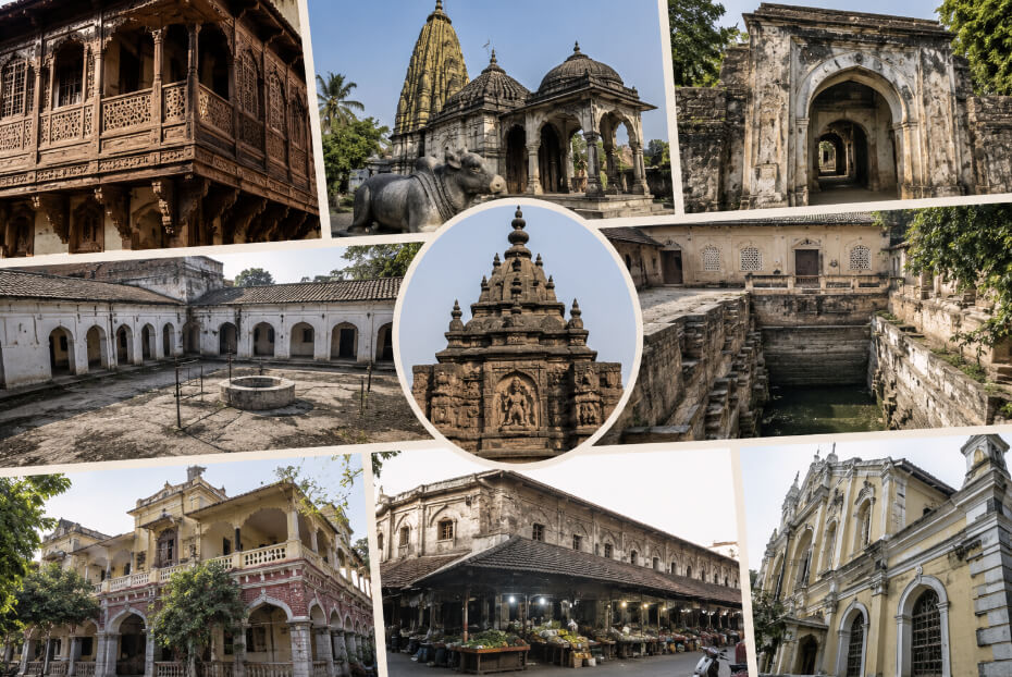
The physical remains of Malkapur's medieval fortifications provide concrete evidence of its strategic importance. The fort, believed to have been constructed during the 12th century, originally featured twelve entrance gates, earning it the local designation Baradari. One of these gates bore an inscription indicating its construction in 1729 during the reign of Muhammad Malikkhan.
The fortification enclosed the old town completely, with ramparts constructed of dressed stone. The Nalganga River provided natural protection on three sides, while stronger defensive walls were erected on the land-facing approach. Of the original twelve gates, only three survived into the modern period: Mughal Darwaja, Mohanpura Darwaja, and Gandhinagar Darwaja.
The Mughal Darwaja, positioned on the northern side near the river, includes guard chambers and structures that may have served as horse stables or travellers' inns. The bastions adjacent to these gates feature gun loopholes, indicating modifications for firearms that likely occurred during the 18th century.
Maratha Period and Military Encounters
The town's strategic location made it a focal point during the Maratha expansion into Vidarbha.
In 1761, Malkapur possessed sufficient wealth to pay Rs. 60,000 to the army of Raghunathrao for exemption from plunder.
This substantial payment demonstrates both the town's economic capacity and its vulnerability to military campaigns.
Raghunathrao, who later served briefly as Peshwa from 1773 to 1774, led extensive northern campaigns requiring continuous financial support from towns along his military routes.
The Nizam of Hyderabad maintained a substantial military presence in Malkapur, stationing approximately 20,000 men in this frontier district of his dominions. This garrison strength reflected the strategic importance of controlling access routes between the Deccan plateau and the territories to the north.
In 1803, Daulatrao Shinde and Raghuji Bhosle encamped near Malkapur when British envoy Colonel Collins presented General Arthur Wellesley's ultimatum before departing Shinde's camp.
This diplomatic encounter preceded the Second Anglo-Maratha War, positioning Malkapur as a witness to the breakdown of negotiations that led to British military intervention.
The town experienced violent communal conflicts during the early 19th century. The most documented incident occurred in 1837, originating from an earlier confrontation at the Pimpalgaon fair in 1825, when a Muslim individual shot dead a Rajput of Dattala who had insulted him.
This killing generated a blood feud that culminated twelve years later when Lal Singh of Dattala assembled approximately 3,000 Hindu fighters to seek revenge. The Sikh community of Nanded on the Godavari River contributed 500 fighters to this force.
The initial assault on Malkapur involved street fighting, burning, and property destruction, though casualties remained relatively limited. Muslim reinforcements arrived from neighbouring towns, particularly a strong contingent from Burhanpur.
The local police and militia under the talukdar proved powerless to contain the violence. Detachments of the Nizam's army under Major Arthur Wyndham intervened, finding Malkapur deserted. The Muslim population had been expelled, while Rajput forces had withdrawn to Dattala, where they subsequently engaged in combat with the military forces.
This incident exemplified the persistent conflicts between zamindars, rural talukdars, Rajputs and Muslims during the period between the early 19th century and the Assignment of Berar to the East India Company in 1853.
Administrative Transitions and British Control
The transfer of Berar to British administration occurred through multiple treaty arrangements. The initial assignment in 1853 resulted from the Nizam's inability to maintain the Hyderabad Contingent, a military force maintained under treaty obligations with the British.
The British Government advanced funds for troop payments, accumulating debts of Rs. 45 lakhs by 1853.
The treaty of 1853 assigned districts yielding a gross revenue of Rs. 50 lakhs to the East India Company, with the revenue designated for maintaining the Hyderabad Contingent and settling outstanding claims.
Malkapur became part of this assigned territory, transitioning from Nizam administration to Company control.
The arrangement proved administratively complex, requiring annual accounts to be rendered to the Nizam with any surplus revenue returned to him. These accounting requirements generated continuous difficulties and disputes. Following the Nizam's cooperation during the 1857 uprising, a revised treaty was concluded in 1860.
This treaty cancelled Rs. 50 lakhs of debt owed by the Nizam, returned certain districts to the Hyderabad authority, but maintained British control over Berar as a trust for purposes specified in the 1853 treaty.
The definitive transfer occurred in 1902 when the Nizam permanently leased Berar to the British in exchange for an annual payment of Rs. 25 lakhs. The agreement, signed on November 5, 1902, by Lieutenant-Colonel Sir David Barr on behalf of the Government of India and Maharaja Sir Kishen Prasad representing the Nizam, granted the British full governmental rights over Berar.
On September 17, 1903, Berar was formally added to the Central Provinces, creating the administrative unit of Central Provinces and Berar. This merger ended any remaining connection between Malkapur and the Hyderabad administration.
During British administration, Malkapur developed as a railway station on the Bombay-Nagpur broad-gauge line of the Great Indian Peninsula Railway. The line connecting Bhusawal to Nagpur opened in 1867, positioning Malkapur at a distance of 308 miles from Bombay and 213 miles from Nagpur. This railway connection transformed the town's commercial prospects, particularly for cotton trade.
Malkapur became recognised as one of the largest cotton producers in the region, earning the designation "White Gold of Vidarbha" during the British era. Towns such as Khamgaon and Malkapur evolved into important cotton trading hubs, connecting Vidarbha to broader imperial markets.
The establishment of civic administration followed colonial patterns. A municipality was formed in Malkapur in 1884, operating under the Bombay District Municipal Act of 1901.
This municipal council assumed responsibility for water supply, sewerage, road construction, and property taxation within the town limits.
The municipality administered 12,879 houses according to subsequent census data, providing basic amenities to a growing urban population. The civic authority structure reflected British administrative practices transplanted to provincial towns throughout the empire.
Religious and Cultural Institutions
The architectural and religious landscape of Malkapur preserved evidence of patronage by local ruling families.
The Nemiwant family, awarded vatandari over Malkapur and surrounding areas by the Nizam during the 18th century, constructed several significant structures.
The grant occurred around 1734 when Hyderabad served as the Nizam's capital. Srinivasrao Nemiwant received authority over Malkapur, Kund, Dharangaon, Badoda, Panhera and Rajura.
The magnificent Mothi Haveli, Lahan Haveli, and Sri Ram Temple in the Durga Nagar area demonstrate the family's wealth and influence. An inscription in the Ram temple confirms the vatandari grant to Raje Nemiwant.
The Mallikarjuna temple houses the Shiva Linga discovered during haveli construction. Despite attempts to relocate the Linga to a more appropriate temple site, the sacred object could not be moved from its original location. According to recorded accounts, a senior family member received a vision in which Shiva declared the Linga's eternal presence at that location and warned against removal.
Consequently, the temple was constructed in the available space, while a separate structure in black stone was erected nearby housing a Panchamukhi Shiva Linga. The marks left by the spade that initially struck the Linga during excavation reportedly remain visible.
An ancient Durga temple exists in the same locality, where the deity is described as self-manifested. This temple stands adjacent to the fort wall, suggesting its incorporation into defensive planning or its predating of fortification construction.
The Gauri-Shankar Temple, constructed by the Saoji family, features sculptural depictions of the Ganga's descent to earth. Local traditions record that Sant Gajanan Maharaj of Shegaon visited the house of Vishnusa Saoji, as mentioned in the prose version of Gajanan Maharaj's life history written by Sant Dasganu Maharaj.
The Dattatreya Temple contains the samadhi of Sant Ganga Bharati, who is identified as a beloved disciple of Sant Gajanan Maharaj. According to hagiographical accounts, Ganga Bharati suffered from leprosy and received healing through the intervention of Gajanan Maharaj. Following his cure, Ganga Bharati established residence at Malkapur as directed by his guru, where he constructed the temple that became his final resting place.
Gurudwara Kadamsar Sahib preserves the memory of Guru Gobind Singh's visit to Malkapur approximately 400 years ago. Local tradition records that during the reign of Nimwant, the region's water supply suffered from excessive salinity. The king, seeking a solution, consulted a fakir named Lal Shah, who advised him that Guru Gobind Singh was present in nearby Burhanpur and possessed divine authority to resolve the water problem.
The king travelled to Burhanpur and requested the Guru's assistance. Guru Gobind Singh accepted the invitation and came to Malkapur, where he ordered the digging of a well. Sweet water emerged from this well, and according to belief, the water quality throughout Malkapur subsequently improved. The tree under which Guru Gobind Singh rested and the well remain at the gurudwara site. Documentation showing land grants made to Guru Gobind Singh by the king reportedly survives in the gurudwara's archives.
Infrastructure development during the British period included the construction of two bridges connecting the eastern Salipura and northern Parpeth sections of the town. These bridges, attributed to Raghuji Bhonsale, facilitated movement across the Nalganga River that divides Malkapur. The bridges remained in functional condition into the modern period, demonstrating the quality of their construction. The Lalbagh farm area contains a stepped well representing the architectural practices of the period, featuring elaborate stonework and providing a secure water source.
The Nalganga Dam and reservoir were constructed in 1967 as part of irrigation projects implemented by the Maharashtra government.
The earthfill gravity dam, with a length of 2,516 metres and a height of 29.8 metres above the lowest foundation, created a reservoir with gross storage capacity of 71.86 million cubic metres.
The project designation "Nalganga D-01216" identified it within the state's irrigation infrastructure network. The dam's purpose focused exclusively on irrigation, with water distributed through the Nalganga project to benefit agricultural lands in the Motala Taluka area.
A trial-cum-demonstration farm was established at Shelapur in February 1965 to develop improved cropping patterns under irrigation and demonstrate suitable cultivation methods for crops receiving water from the project.
Economic Development and Modern Characteristics
Cotton cultivation and processing dominated Malkapur's economic activities from the colonial period through the 20th century.
The favourable soil conditions and climate supported cotton as the primary cash crop, with ginning operations and cotton presses established to process the harvest.
Paper manufacturing emerged as a significant industrial sector, with multiple mills producing kraft paper, millboard paper, and sundry papers used for file folders, cake bases, registers and related products.
The location of these mills in the MIDC area at Dasarkhed demonstrated the continuation of industrial development after independence.
The 2011 census recorded Malkapur's population as 67,740, comprising 34,693 males and 33,047 females, yielding a sex ratio of 953 females per 1,000 males.
The literacy rate reached 87.9 percent, exceeding both the district average of 83.4 percent and the state average of 82.34 percent. Male literacy stood at 92.01 percent while female literacy reached 83.7 percent.
The child population aged 0-6 years numbered 8,984, representing 13 percent of the total population, with a child sex ratio of 897 females per 1,000 males.
Religious composition reflected the town's historical development under successive ruling authorities. The Hindu population numbered 31,720, representing 46.83 percent of residents. The Muslim population totalled 30,915, comprising 45.64 percent. Smaller communities included 3,061 Buddhists, 1,575 Jains, 98 Christians, and 24 Sikhs.
This religious distribution demonstrated remarkable balance between the two major communities, a demographic pattern established during the town's formative period under Islamic administration and maintained through subsequent political transitions.
The working population of 21,268 engaged primarily in activities classified as main work, with 81.9 percent deriving employment or earnings exceeding six months annually. Agriculture remained significant, with 795 cultivators owning or co-owning land and 2,322 agricultural labourers.
The category of other workers numbered 13,896, indicating diversification of economic activities beyond traditional agricultural employment. The household industries sector employed 398 individuals, suggesting continuation of artisanal production alongside modern industrial establishments.
Municipal administration divided the town into 27 wards for electoral purposes, with elections conducted every five years. The municipal council maintained authority over 12,879 houses, providing water supply, sewerage, road maintenance and property taxation services.
Ward populations ranged from 1,863 to 4,387 residents, with literacy rates varying from 59.8 percent to 89.3 percent across different wards. Sex ratios showed variation between wards, with Ward 16 recording the highest ratio of 1,014 females per 1,000 males while Ward 8 registered the lowest at 898.
The fortified town that emerged during medieval Islamic administration evolved through Maratha conflicts, Nizam frontier control, and British colonial reorganisation to become a modern municipal centre maintaining agricultural and industrial functions.
The physical remnants of twelve-gated fortifications, religious structures serving multiple faith communities, and bridges crossing the Nalganga River constitute the visible heritage of this administrative and commercial hub in Vidarbha.
References
Ain-i-Akbari. (n.d.). Third volume of Akbarnama. Retrieved from https://en.banglapedia.org/index.php/Ain-i-Akbari
Berar Province. (2004). Wikipedia. Retrieved from https://en.wikipedia.org/wiki/Berar_Province
Buldhana District. (2004). Wikipedia. Retrieved from https://en.wikipedia.org/wiki/Buldhana_district
Central Provinces and Berar. (1910). Old Buldhana District Gazetteer. Government Press.
Census of India. (2011). Malkapur population data. Office of the Registrar General & Census Commissioner. Retrieved from https://www.censusindia.co.in/towns/malkapur-population-buldana-maharashtra-802665
Dorle, P. S. (n.d.). The original story of Malkapur town. Retrieved from https://vivekanandasevamandal.in/about-malkapur/
Farooqui Dynasty. (2007). Wikipedia. Retrieved from https://en.wikipedia.org/wiki/Farooqui_dynasty
Gurudwara Kadamsar Sahib. (n.d.). Historical gurudwaras. Retrieved from https://www.historicalgurudwaras.com/GurudwaraDetail.aspx?gid=8400
India Water Resources Information System. (n.d.). Dams in Maharashtra. Retrieved from https://indiawris.gov.in/wiki/doku.php?id=dams_in_maharashtra
Indpaedia. (2010). Berar. Retrieved from http://indpaedia.com/ind/index.php/Berar
Malkapur Fort. (2010). Jayaram trekking blog. Retrieved from http://jayaram-trekking.blogspot.com/2010/03/malkapur-fort.html
Malkapur Railway Station. (2011). Wikipedia. Retrieved from https://en.wikipedia.org/wiki/Malkapur_railway_station
Maharashtra Gazetteers Department. (1999). Buldhana District Gazetteer: History - British Period. Retrieved from https://gazetteers.maharashtra.gov.in/cultural.maharashtra.gov.in/english/gazetteer/BULDHANA/his_british%20period.html
Maharashtra Gazetteers Department. (1999). Buldhana District Gazetteer: Malkapur. Retrieved from https://gazetteers.maharashtra.gov.in/cultural.maharashtra.gov.in/english/gazetteer/BULDHANA/places_Malkapur.html
Maharashtra Gazetteers Department. (1999). Buldhana District Gazetteer: Railways. Retrieved from https://gazetteers.maharashtra.gov.in/cultural.maharashtra.gov.in/english/gazetteer/BULDHANA/comm_railways.html
Maharashtra Tourism. (2024). Buldhana district. Retrieved from https://maharashtratourism.gov.in/districts/buldhana/
Nalganga Dam. (2010). Wikipedia. Retrieved from https://en.wikipedia.org/wiki/Nalganga_Dam
Nalganga Reservoir. (n.d.). Wikimapia. Retrieved from http://wikimapia.org/11308063/Nalganga-Reservoir
National Water Development Agency. (2018). Wainganga-Nalganga river linking project. Retrieved from https://www.nwda.gov.in/upload/uploadfiles/files/Chapter-2.pdf
Raghunath Rao. (2005). Wikipedia. Retrieved from https://en.wikipedia.org/wiki/Raghunath_Rao
Raghuji I. (2007). Wikipedia. Retrieved from https://en.wikipedia.org/wiki/Raghuji_I
Second Anglo-Maratha War. (2004). Wikipedia. Retrieved from https://en.wikipedia.org/wiki/Second_Anglo-Maratha_War
The News Dirt. (2025). History of Buldhana: From prehistoric times to the present day. Retrieved from https://www.thenewsdirt.com/post/history-of-buldhana-from-prehistoric-times-to-the-present-day
Water Quality Assessment. (n.d.). Nalganga reservoir. Retrieved from https://ijcrt.org/papers/IJCRTL020054.pdf
Wisdomlib. (2025). Malkapur city information. Retrieved from https://www.wisdomlib.org/cities/malkapur-3725


I was born in Malkapur and visited my school education there. Now I'm setteled in Germany.
Since my school days in Malkpur I was looking for Malkapur history.
Now, at last, I found it woth your kind help.
I'm proud to be an Malkapu-wala.
Thak you very much for your researnch and publication.
Namaskar
Damodar Paralkar